G318 Elevation Chart & Acclimatization Guide
Spanning 2,142 kilometers from Chengdu’s basin (500m) to the roof of the world at Dongda Pass (5,130m) and Lhasa (3,650m). Explore the definitive day-by-day altitude profile, river valley sleep sanctuaries, clinical pharmacology, emergency hospital coordinates, and how to steer clear of predatory oxygen extortion.

The 2,142km Sichuan-Tibet Elevation Stepping Stone
Unlike flying directly into Lhasa (3,650m)—which shocks the circulatory system with instantaneous 35% hypoxia—driving G318 follows a deliberate roller-coaster topography. By climbing high mountain crests by day and dropping into oxygen-rich river canyons at night (Batang 2,580m, Bomi 2,750m, Nyingchi 2,900m), your body naturally synthesizes red blood cells with near-zero risk of severe altitude sickness.
How You Enter Tibet Dictates Your Acclimatization Rhythm
Western Wilderness Medical Society (WMS) literature confirms that rate of ascent is the single greatest determinant of Acute Mountain Sickness (AMS). Here is how the three entry methods compare scientifically:
Catapults human physiology from sea level to 3,650m in under 3 hours. Referred to in medical forums as a "precipitous hypoxia strike." Over 50% of unmedicated arrivals suffer acute migraines, nausea, and disorientation within 6–12 hours, frequently forcing itinerary cancellations on Day 1.
While trains feature diffuse oxygen enrichment, crossing the 5,068m Tanggula Pass maintains high equivalent cabin altitudes. Passengers disembark in Lhasa without having developed true capillary density or red blood cell (erythropoietin) compensation.
Ascending eastward across the Hengduan Mountains allows natural, progressive cardiovascular adaptation—provided your itinerary respects the "Climb High, Sleep Low" rule and navigates the extreme sawtooth elevation oscillations.
The 318 Sawtooth Elevation Dilemma: Core Overnight Nodes & Risk Ratings
National Highway 318 is not a steady slope; it violently oscillates between 2,500m river gorges and 5,000m glacial passes. Here is the verified international overland sleeping strategy:
| Route Node | Elevation | Terrain Environment | Overnight Strategy | AMS Risk Level |
|---|---|---|---|---|
| Chengdu (成都) | ~500m | Sichuan Basin Plains | Stay 1–2 Nights (Baseline check) | Zero Risk |
| Kangding (康定) | 2,560m | Dadu River High Gorge | Mandatory First Sleep (1st Tier) | Low Risk |
| Zheduo Pass (折多山) | 4,290m | Kham Mountain Crest | Transit Only — 30 Min Max | High Risk |
| Xinduqiao (新都桥) | 3,300m | Wide Highland Basin | Cautious Sleep (Require Room Oxygen) | Moderate Risk |
| Litang (理塘) | 4,014m | Wuliang River Plateau Plateau | ⚠️ STRICTLY DO NOT SLEEP (Lunch only) | CRITICAL RISK |
| Batang (巴塘) | 2,580m | Jinsha River Valley Lowlands | Strongly Recommended Sleep Haven | Low Risk |
| Markam (芒康) | 3,850m | Lancang River Folded Tableland | Permitted for Acclimatized Travelers | Moderate-High |
| Dongda Pass (东达山) | 5,130m | Highest G318 Mountain Pass | Rapid Transit — Do NOT Linger | EXTREME RISK |
| Bomi (波密) | 2,725m | Parlung Tsangpo Forest Valley | Strongly Recommended (Oxygen Oasis) | Low Risk |
| Nyingchi (林芝巴宜) | 2,900m | Southeastern Tibet Alluvial Oasis | Premier Pre-Lhasa Buffer Oasis | Very Low Risk |
| Lhasa (拉萨) | 3,650m | Lhasa River Basin Plateau | First 48h Total Rest, Zero Rapid Walking | Moderate Risk |
Every County, Town & River Valley on Highway 318
Detailed kilometer-by-kilometer elevations, terrain categories, ambient oxygen ratios, sleep safety indexes, and immediate clinical guidance.
It Is Not How High You Drive, It Is Where You Sleep (Sleeping Gain ≤ 500m / Day)
Briefly crossing a 5,000m mountain pass (like Dongda 5,130m) for 45 minutes triggers minor transient breathlessness. However, nocturnal hypoxemia during sleep is what precipitates life-threatening HAPE and HACE. WMS clinical guidelines mandate that above 3,000m, your overnight sleeping altitude should not increase by more than 500 meters (1,640 ft) per 24 hours. This is why sleeping in Litang (4,014m) is a notorious AMS trigger for first-timers; experienced overlanders always descend to deep river valleys like Yajiang (2,600m) or Batang (2,580m) for restorative low-stress sleep.
| Location & Chinese Name | Elevation & Oxygen Level | KM Milestone | Sleep Safety Index | Clinical Acclimatization Guidance |
|---|---|---|---|---|
Chengdu (Expedition Departure) 成都平原 (起点)Sichuan Basin Lowland | 500 m/ 1,640 ft Ambient O2: ~100% of sea level | G318 · KM 0 | Safe Sleep Haven | Full sea-level oxygen. Baseline blood oxygen saturation (SpO2 98-99%). Final gear & medication check. 🏥 Emergency Point: West China Hospital (华西医院) |
Tianquan & Erlang Foothills 天全 / 二郎山前Lush Subtropical Foothills | 780 m/ 2,559 ft Ambient O2: ~98% of sea level | G318 · KM 180 | Safe Sleep Haven | Abundant moisture and dense bamboo-fir vegetation. Zero altitude impact. 🏥 Emergency Point: Tianquan County People's Hospital |
Dadu River Valley / Luding 大渡河谷 / 泸定Semi-Arid Subtropical Gorge | 1,330 m/ 4,363 ft Ambient O2: ~92% of sea level | G318 · KM 240 | Safe Sleep Haven | Deep low-altitude valley after Erlang Tunnel. Ideal low-stress acclimatization gateway. 🏥 Emergency Point: Luding County People's Hospital |
Kangding City 康定市 (情歌故乡)Narrow Mountain River Gorge | 2,560 m/ 8,398 ft Ambient O2: ~76% of sea level | G318 · KM 320 | Safe Sleep Haven | Standard Night 1 sleep station. Mild threshold where bodies begin producing erythropoietin (EPO). 🏥 Emergency Point: Ganzi Prefecture People's Hospital (三甲) |
Zheduo Mountain Pass 折多山垭口First 4,000m+ Alpine Crest | 4,298 m/ 14,101 ft Ambient O2: ~59% of sea level | G318 · KM 360 | Avoid Sleep / Transit | The official gateway to Tibetan plateau. Photo stop strictly under 20 mins. Do not jog or jump. 🏥 Emergency Point: Kangding Emergency Center (40 min descent) |
Xinduqiao Town 新都桥镇 (摄影走廊)Highland Poplar Valley | 3,450 m/ 11,318 ft Ambient O2: ~68% of sea level | G318 · KM 395 | Caution (Oxygen Req) | Night 2 sleep test. SpO2 typically drops to 85-90%. Diffused oxygen hotel rooms strongly recommended. 🏥 Emergency Point: Xinduqiao Central Health Center / Kangding |
Yajiang & Yalong River Canyon 雅砻江大峡谷 / 雅江Deep River Canyon Drop | 2,600 m/ 8,530 ft Ambient O2: ~75% of sea level | G318 · KM 465 | Safe Sleep Haven | Drops 850m vertically from surrounding passes. Excellent emergency sleep haven if Xinduqiao feels harsh. 🏥 Emergency Point: Yajiang County People's Hospital |
Kazila Mountain Ridge 卡子拉山脊线Rolling High-Altitude Grassland | 4,718 m/ 15,479 ft Ambient O2: ~55% of sea level | G318 · KM 560 | Avoid Sleep / Transit | Driving above the clouds. Windchill is severe year-round. Stay inside heated vehicle between viewpoints. 🏥 Emergency Point: Yajiang / Litang mobile ambulances |
Litang (World's High City) 理塘县 (世界高城)Expansive Maoya Alpine Basin | 4,014 m/ 13,169 ft Ambient O2: ~61% of sea level | G318 · KM 600 | Avoid Sleep / Transit | High risk of nocturnal insomnia & headaches for newcomers. Visit monasteries by day; descend to Batang to sleep. 🏥 Emergency Point: Litang People's Hospital (高原病专科) |
Batang & Jinsha River Valley 金沙江干热河谷 / 巴塘Lush Fruit Valley Basin | 2,580 m/ 8,464 ft Ambient O2: ~76% of sea level | G318 · KM 780 | Safe Sleep Haven | The golden restorative sleep haven before entering Tibet. Dramatic oxygen rebound allows body deep tissue recovery. 🏥 Emergency Point: Batang County People's Hospital |
Jinsha River Border Bridge 金沙江大桥 (川藏分界)Provincial Border Canyon | 2,450 m/ 8,038 ft Ambient O2: ~77% of sea level | G318 · KM 815 | Safe Sleep Haven | Physical entrance into Tibet Autonomous Region (TAR). Official security & Tibet Travel Permit verification checkpoint. 🏥 Emergency Point: Markam Border Clinic |
Markam County (TAR) 芒康县城 (西藏首站)Three Parallel Rivers Highland | 3,850 m/ 12,631 ft Ambient O2: ~63% of sea level | G318 · KM 890 | Caution (Oxygen Req) | Night 4 or 5 sleep. Keep physical exertion low. Drink 3-4 liters of electrolyte water. 🏥 Emergency Point: Markam County People's Hospital |
Dongda Mountain Pass (Highest Point) 东达山垭口 (全线最高点)Himalayan Glacial Permafrost | 5,130 m/ 16,830 ft Ambient O2: ~51% of sea level | G318 · KM 1250 | Avoid Sleep / Transit | The Everest-tier altitude peak of Highway 318. Oxygen partial pressure is halved. Strict 10-minute maximum stop. 🏥 Emergency Point: Left Zogang Emergency Post (35km descent) |
Lancang (Mekong) River Gorge 澜沧江大峡谷Red Rock Canyon Drop | 2,600 m/ 8,530 ft Ambient O2: ~75% of sea level | G318 · KM 1000 | Safe Sleep Haven | Rapid descent from Lawu Pass. Ear pressure pops as air density surges. Oxygen recovery zone. 🏥 Emergency Point: Zogang County Hospital Substation |
Zogang County 左贡县城Yuqu River Plateau Basin | 3,800 m/ 12,467 ft Ambient O2: ~64% of sea level | G318 · KM 1050 | Caution (Oxygen Req) | Quiet transit sleep after conquering Dongda Pass. Oxygen hotel rooms recommended. 🏥 Emergency Point: Zogang County People's Hospital |
Yela Pass & 72 Hairpin Turns 业拉山 / 怒江七十二拐Switchback Crest down to Gorge | 4,658 m/ 15,282 ft Ambient O2: ~56% of sea level | G318 · KM 1390 | Avoid Sleep / Transit | Dramatic 1,500m plunge into Nujiang River canyon. Keep seatbelts fastened and avoid sudden standing. 🏥 Emergency Point: Baxoi People's Hospital |
Nujiang (Salween) River Gorge 怒江峡谷底Arid Granite Canyon Floor | 2,740 m/ 8,989 ft Ambient O2: ~74% of sea level | G318 · KM 1430 | Safe Sleep Haven | Canyon warmth and rapid oxygen relief. Headaches from Yela Pass usually dissipate completely here. 🏥 Emergency Point: Baxoi Canyon Emergency Point |
Baxoi County 八宿县城Baima River Oasis | 3,280 m/ 10,761 ft Ambient O2: ~69% of sea level | G318 · KM 1480 | Safe Sleep Haven | Balanced, comfortable highland sleep station after high pass switchbacks. 🏥 Emergency Point: Baxoi County People's Hospital |
Ranwu Glacial Lake 然乌湖湿地Turquoise Glacial Moraine Lake | 3,850 m/ 12,631 ft Ambient O2: ~63% of sea level | G318 · KM 1560 | Caution (Oxygen Req) | High humidity and chilly glacier winds at night. Keep warm to prevent hypothermia-induced shivering. 🏥 Emergency Point: Ranwu Town Health Clinic / Bomi |
Palong Zangbo / Bomi (Spruce Eden) 帕隆藏布河谷 / 波密Temperate Virgin Rainforest | 2,750 m/ 9,022 ft Ambient O2: ~75% of sea level | G318 · KM 1650 | Safe Sleep Haven | Known as the 'Tibetan Switzerland'. Dense pine forests pump high negative oxygen ions. Best sleep in Tibet. 🏥 Emergency Point: Bomi County People's Hospital |
Nyingchi City / Bayi (Tibetan Jiangnan) 林芝市 / 八一镇Fertile Yarlung River Valley | 2,900 m/ 9,514 ft Ambient O2: ~73% of sea level | G318 · KM 1810 | Safe Sleep Haven | Large modern city below 3,000m. Grade-A Tertiary Hospital on standby. 99% of travelers experience zero AMS. 🏥 Emergency Point: Nyingchi People's Hospital (三甲医院) |
Lhasa (The Holy City & Potala) 拉萨圣城 (布达拉宫)Sunlit Kyi Chu Plateau Basin | 3,650 m/ 11,975 ft Ambient O2: ~65% of sea level | G318 · KM 2142 | Safe Sleep Haven | Final destination. Because you climbed gradually over 10-12 days via G318, your body is fully acclimatized. 🏥 Emergency Point: Tibet Autonomous Region People's Hospital (三甲旗舰) |
"Where Do I Sleep?" Day-by-Day Sleeping Gain vs. Pass Altitude
When international travelers see promotional banners proclaiming "Highest Point: Dongda Pass 5,130m", their primary psychological terror is: "Do I have to sleep at 5,130m?" The answer is an emphatic NO. CDC and WMS clinical evidence proves that daytime pass exposure triggers only transient breathlessness—nocturnal sleeping altitude is the true determinant of life-threatening AMS, HAPE, and HACE. Below is the verified day-by-day 24-hour sleeping gain calculation for the classic G318 route:
| Day & Route Leg | Daytime Peak Pass | Overnight Sleep Base | 24h Sleeping Altitude Gain (Δ Alt) | WMS 2024 Safety Evaluation | Plan B Lower-Altitude Fallback (紧急下撤避险点) |
|---|---|---|---|---|---|
| Day 1: Chengdu Departure | 500m (Basin plains) | Chengdu (500m / 1,640 ft) | ±0m baseline | ✓ Zero AMS Risk (100% O2) | None needed · Basin baseline elevation |
| Day 2: Chengdu → Kangding | Erlang Tunnel (2,170m) | Kangding (2,560m / 8,398 ft) | +2,060m (from basin) | ✓ Safe Threshold (< 2,800m) | Luding Dadu Gorge (1,330m) 40 min drive east (-1,230m drop) |
| Day 3: Kangding → Xinduqiao | Zheduo Pass (4,298m) | Xinduqiao (3,300m / 10,826 ft) | +740m net gain | ⚠️ Moderate Caution (Diffuse O2 Recommended) | Yajiang Canyon floor (2,600m) 45 min drive west (-700m drop) |
| Day 4: Xinduqiao → Litang → Batang | Kazila (4,718m) & Litang (4,014m) | Batang Valley (2,580m / 8,464 ft) | -720m RESTORATIVE DROP! | 🌟 Masterstroke: Deep Valley Oxygen Recovery | Jinsha River orchards (2,450m) Sanctuary itself · Zero emergency drop needed |
| Day 5: Batang → Markam | Haizi Pass (4,685m) | Markam (3,850m / 12,631 ft) | +1,270m net gain | ⚠️ Tolerable after Batang recovery; hydrate well | Zhubalong / Jinsha Gorge (2,450m) 40 min drive east (-1,400m drop) |
| Day 6: Markam → Zogang | Dongda Pass (5,130m — Peak) | Zogang (3,800m / 12,467 ft) | -50m net drop | ✓ High pass crossed by day, stable night altitude | Lancang (Mekong) Gorge floor (2,600m) 35 min drive (-1,200m drop) |
| Day 7: Zogang → Baxoi | Yela Pass (4,658m) & 72 Turns | Baxoi (3,280m / 10,761 ft) | -520m net drop | ✓ Restful river oasis sleep | Nujiang (Salween) Gorge floor (2,740m) 35 min drive (-540m drop) |
| Day 8: Baxoi → Ranwu → Bomi | Ranwu Lake (3,850m) | Bomi (2,725m / 8,940 ft) | -555m RESTORATIVE DROP! | 🌟 Spruce rainforest with high oxygen saturation | Tongmai Gorge floor (2,050m) 45 min drive west (-675m drop) |
| Day 9: Bomi → Nyingchi (Bayi) | Tongmai Gorge (2,050m) | Nyingchi (2,900m / 9,514 ft) | +175m mild gain | ✓ Pre-Lhasa biological buffer zone (< 3,000m) | Yarlung Tsangpo Valley (2,500m) Grade-3A Hospital Standby (< 3,000m safe zone) |
| Day 10: Nyingchi → Lhasa | Mila Tunnel (3,750m) | Lhasa (3,650m / 11,975 ft) | +750m arrival | ✓ Arrive 100% acclimatized; zero acute shock | Lhasa River Basin (3,650m) Autonomous Region People's Hospital (3A ICU) |

The 2:00 AM Midnight Hypoxia Action Protocol: Why Desaturation Strikes at Night
Over 85% of severe altitude emergencies do not happen under bright sunshine atop mountain passes—they strike between 1:00 AM and 4:00 AM in your hotel bed. During slow-wave sleep, the brainstem naturally reduces respiratory drive, inducing Cheyne-Stokes periodic breathing. In high plateau towns like Xinduqiao (3,300m) or Markam (3,850m), blood oxygen plummets rapidly. If you or your partner wake up gasping for air, follow this exact 4-step emergency sequence:

Immediately stack 2 to 3 pillows behind your back to raise your chest at a 45-degree angle. Never lie flat on your back during acute hypoxia. A supine position increases pulmonary capillary hydrostatic pressure, worsening fluid extravasation into the lung alveoli and aggravating HAPE.
Turn on the room's diffuse oxygen switch (弥散供氧), which raises ambient room oxygen by 3%–4%. If severe shortness of breath persists, plug in the bedside oxygen concentrator via nasal cannula at 2.0 to 3.0 Liters/min. Add purified water to the humidification bottle to prevent dry nasal bleeding in arid plateau air.
Warm the fingertip with your hands (cold peripheral vasoconstriction produces false low readings) and test for 30 seconds. If SpO2 remains persistently below 75% despite breathing oxygen, or is accompanied by chest tightness, a resting pulse > 120 bpm, or audible gurgling in the throat, you are in acute decompensation.
Do not wait for sunrise. Wake up your travel partner or driver immediately. Pack warm layers and drive down along your leg's mapped Plan B corridor (e.g. from Xinduqiao down into Yajiang Canyon, or from Markam down into Jinsha Valley). Dropping 500 to 1,000 vertical meters provides instant alveolar oxygen recovery that no medicine can match.
High Altitude Susceptibility: Who is Most at Risk?
Altitude sickness does not correlate with general athletic fitness. Here is what clinical high-altitude medicine proves about who suffers the worst initial hypoxia and why.
Physiological Mechanism: CDC & WMS 2024 studies confirm: Physical fitness provides zero immunity to AMS. Large skeletal muscle mass dramatically increases resting basal oxygen consumption. Highly fit athletes also tend to ignore early warning fatigue and push through pacing limits.
Physiological Mechanism: Cerebral hypoxia impairs the frontal cortex before physical collapse occurs. Victims exhibit irrational overconfidence, denial of obvious symptoms, aggressive behavior, and refusal to descend until acute HACE (brain edema) sets in.
Physiological Mechanism: Hot showers cause intense peripheral vasodilation, stealing blood flow from hypoxic brains and triggering syncope (fainting). Post-shower shivering rapidly breaks down respiratory mucosal cilia defenses, triggering acute lung infection and fatal HAPE in hours.
Physiological Mechanism: Fear triggers rapid, shallow hyperventilation, blowing off excess carbon dioxide (CO2). This induces respiratory alkalosis, paradoxically constricting cerebral blood vessels and causing intense dizziness and limb numbness.
Physiological Mechanism: Respiratory drive naturally slows during deep sleep. For OSA sufferers, repeated upper airway collapses in 3,500m+ environments cause nocturnal SpO2 to plummet to 50-60%, waking up with blinding morning migraines.
Physiological Mechanism: Entering high altitude with pre-existing pulmonary endothelial inflammation multiplies the risk of High Altitude Pulmonary Edema (HAPE) by 400%.
Physiological Mechanism: Clinical studies prove healthy seniors experience lower rates of severe AMS than 20-year-olds. Slower metabolic pace and age-related cerebral space buffer brain swelling more effectively.
The Lake Louise Score (LLS) & Symptom Red-Flag Triage
In international mountain medicine (CDC Yellow Book & Wilderness Medical Society 2024 Guidelines), Acute Mountain Sickness is graded objectively using the Lake Louise Score (LLS). A diagnosis of AMS requires a headache plus at least one other symptom. Use this 3-color clinical triage matrix to know when to rest, when to stop ascending, and when to evacuate downhill immediately:
Mild Hypoxia Adaptation
Clinical Signs: Mild dull headache after crossing a high pass, slight breathlessness when carrying luggage upstairs, mild dry mouth, light nocturnal sleep awakening. SpO2 typically registers 80%–88%.
Active Mountain Sickness
Clinical Signs: Throbbing bilateral headache unresponsive to regular painkillers, nausea, total loss of appetite, persistent dizziness, insomnia with frequent gasping awakenings. SpO2 drops to 70%–79%.
HACE / HAPE Emergency
Clinical Signs:
• Critical Hypoxia: SpO2 persistently < 75% at rest, or acute desaturation unresponsive to low-flow oxygen.
• HACE: Ataxia (failing heel-to-toe walking test), confusion, slurred speech, irrational denial of symptoms (anosognosia).
• HAPE: Severe breathlessness at total rest, rattling chest cough, blue-gray lips/fingernails, pink frothy sputum.


Declaration: Safety is Strictly #1 · Altitude Sickness Can Happen to Anyone & Is Never Shameful
Before boarding your vehicle in Chengdu, every traveler must internalize a fundamental truth of wilderness medicine: Acute Mountain Sickness (AMS) is a pure physiological response of the human body to barometric hypobaric hypoxia. It is never a sign of physical weakness, lack of mental toughness, or personal failure.
Olympic marathon runners, triathletes, military veterans, and even native Tibetan plateau drivers returning after a week in Chengdu can develop acute altitude sickness under rapid ascent. Your blood vessels and alveolar membrane simply need time to adapt. There is zero shame in experiencing symptoms, requesting a rest stop, or asking to descend.
In high-altitude autopsy and rescue case studies, the single most common behavioral trigger of death is concealing symptoms out of fear of delaying the group (怕拖累大家) or appearing soft. Hiding a headache at 5:00 PM allows pulmonary capillary pressure to build unchecked, erupting into fatal nocturnal pulmonary edema (HAPE) by 2:00 AM.
Along 2,142km of wild mountain terrain across Tibetan autonomous prefectures, private 1-on-1 personal medical escorts or personal nurses do not exist. Your survival depends on mutual team transparency, early disclosure, and having objective clinical tools in your own hands.
Traveler Profile Matrix: Different Travelers Fear Different Risks
In international travel communities (Reddit, Tripadvisor, Lonely Planet), foreign travelers along Highway 318 are not one homogenous group. A self-drive road tripper, a solo backpacker, a cyclist crossing 5,000m passes, and a family with children face radically different physiological vulnerabilities and psychological anxieties. Select your profile below to inspect the tailored clinical protocol:
Quick-Scan Master Demographic Matrix (7 Traveler Groups)
Debunking the Top 8 Hypoxia Myths on Highway 318
Medical health institutions know how to minimize biological risk, but rarely understand the day-to-day realities of the G318 itinerary. Tour agencies know the road, but often obscure the medical science. Here, we bridge that gap by dismantling the 8 most dangerous altitude sickness myths believed by foreign travelers:
The Western vs. Chinese Traveler Gap: What International Overlanders Require
Why do domestic Chinese tour descriptions often receive harsh 1-star reviews from Western travelers on Tripadvisor and Reddit? Chinese travel agencies frequently copy-paste domestic marketing slogans without addressing the strict evidence-based medical requirements of international overlanders:
| Operational Dimension | Typical Chinese Budget Tour Approach | International Standard (g318trip.com Protocol) |
|---|---|---|
| Medical Evidence Base | Folk hearsay, 'drink Rhodiola', 'no showers for a week', 'endure it with willpower' | CDC Yellow Book, Wilderness Medical Society (WMS 2024), Lake Louise Score (LLS) Impact: Eliminates dangerous folklore; grounds every decision in objective physiology and clinical data. |
| Oxygen Protocol | Handheld 1L cans, fears of 'oxygen addiction', hidden rental fees for room concentrators | Pressurized 10L-15L medical cylinders, diffuse room oxygen, objective SpO2 < 75% descent cutoff Impact: Treats oxygen as a vital life-safety tool rather than a profit-making commercial commodity. |
| Itinerary Altitude Dynamics | Rushed sightseeing; forcing travelers to sleep high in Litang (4,014m) to save bus fuel | 'Climb High, Sleep Low'; daily sleep gain ≤500m; restorative drops to Batang (2,580m) and Bomi (2,725m) Impact: Prevents nocturnal hypoxia crises, ensuring restful deep sleep and high hemoglobin replenishment. |
| Insurance & Hospital Billing | Domestic basic bus accident insurance; zero guidance on remote hospital cash payments | 5,500m Extreme Altitude Rider; 100% upfront Alipay/cash reimbursement; 3 mandatory stamped tax docs Impact: Prevents total financial denial by Western underwriters upon returning to your home country. |
| Psychological Safety & Ethics | 'Don't complain or delay the group'; travelers suffer in silence out of social embarrassment | Psychological safety doctrine: safety is strictly #1; AMS is purely physiological and never shameful Impact: Encourages early symptom disclosure (LLS 1–3) when simple rest and hydration resolve the issue in 15 mins. |
Timeline of Altitude Sickness Fear Across the 5 Trip Stages
Altitude anxiety is not static—it evolves dynamically from your home living room in London or New York to the midnight hotel rooms of the Tibetan plateau. Here is how fear manifests at each stage and how our protocol resolves it:
Medical Truth: Hypoxia anxiety is magnified by sensationalized media reports. In reality, gradual overland ascent has a 95%+ success rate when planned with river valley sleeping bases.
Medical Truth: Daytime pass height does not matter—overnight sleeping gain is the true driver of acute mountain sickness.
Medical Truth: Transient breathlessness at pass crests is completely normal. Orthostatic syncope occurs when standing abruptly from squats in hypoxic states.
Medical Truth: Nocturnal hypoxia peaks at 2:00 AM due to central respiratory depression (Cheyne-Stokes breathing). Hiding symptoms is the #1 killer.
Medical Truth: 'Reverse Altitude Sickness' (下山醉氧): Blood with high hematocrit suddenly encounters dense sea-level air, inducing benign drowsiness and mild fog.
Exposing Predatory Hypoxia Extortion by Rogue Tour Groups
How low-cost bus tours exploit foreign tourists' genuine fear of altitude sickness to generate thousands of dollars in coerced oxygen and herbal sales. Know your rights.
Why You Cannot Rely on Helicopter Evacuation on Highway 318
Unlike the Nepal Himalayas where commercial civil helicopters sling-evacuate climbers to Kathmandu private hospitals in 1 to 3 hours with direct international insurance billing, the Tibetan Plateau is under strict low-altitude airspace restrictions. There is zero civilian helicopter rescue network for foreign travelers. If severe HAPE or HACE strikes, your survival relies 100% on ground 4WD evacuation over 10 to 30 hours of mountain roads.
| Medical Rescue Dimension | Nepal Himalayas (South Slope) | G318 Sichuan-Tibet Overland (Reality) |
|---|---|---|
| Aerial Evacuation (Air Medevac) | Mature commercial civil helicopters, on-call 24/7 | Strict military airspace ban. Zero civil helicopter rescue for foreigners |
| Transit Mode | Vertical helicopter extraction bypassing rough terrain | 100% ground 4WD ambulances over hair-pin mountain passes |
| Evacuation Time to Hospital | 30 minutes to 3 hours to Kathmandu tertiary ICU | 10 to 30 hours of road transit (vulnerable to mudslides & snow) |
| Language Support | Kathmandu private hospitals staffed with fluent English doctors | Remote county public hospitals communicate almost exclusively in Chinese |
| Insurance Direct Billing (GOP) | Direct billing guarantees accepted by major travel insurers | No direct billing. Patients must prepay 100% upfront in RMB cash / Alipay |
Tiered Public Hospitals Along G318: Addresses & Emergency Phone Lines
Verified landlines and hospital addresses from Chengdu to Lhasa. In China, dialing 120 connects directly to the nearest municipal emergency dispatch center even from foreign SIM cards.
Ganzi Tibetan Autonomous Prefecture People's Hospital
Primary highland emergency center for Eastern Tibet. Hyperbaric oxygen chambers & CT scanners.

High-Altitude Travel Insurance & The Hospital Payment Reality
Navigating medical treatment along Highway 318 involves unique legal, financial, and administrative rules that catch foreign travelers off-guard. Here is the unvarnished reality of insurance riders, cashless billing failures, and upfront hospital payments:
Over 80% of standard travel insurance policies (e.g. basic World Nomads, Allianz Global, AXA) strictly exclude medical coverage for travel or illness occurring above 2,500m or 3,000m.
Western insurers frequently advise travelers: "Just hand your Guarantee of Payment (GOP) letter to hospital reception for direct billing."
To successfully claim reimbursement from your home insurer upon returning, you must collect these exact 3 documents before leaving the hospital:
- Official Tax Invoice (增值税发票): Stamped with the hospital's official red seal.
- Itemized Cost Breakdown (费用明细清单): Detailing medications, tests, and oxygen fees.
- Clinical Diagnostic Record (门诊病历 / 出院小结): Signed by the chief physician.
Chapter 5 of our $39.90 Survival Manual includes pre-written Chinese-English request letters that you can display directly to hospital cashier staff to ensure all 3 tax invoices and diagnostic records are printed and stamped accurately before you leave.
Does Your Travel Insurance Really Cover G318? The 8-Point Verification Checklist
Never assume your regular credit card travel insurance or general vacation policy will pay out on Highway 318. Before departure, contact your underwriter and obtain written confirmation for these 8 critical clauses:
Dongda Pass reaches 5,130m (16,830 ft). Ensure your policy includes an Extreme Altitude Rider covering up to 5,500m or 6,000m. Standard policies cap out at 2,500m and automatically deny claims.
Verify that 'motorized overland driving on high-altitude mountain highways' is covered. Some policies cover trekking on foot but explicitly exclude overland road journeys.
Most insurers require calling a 24/7 hotline prior to hospital admission. Ensure your policy waives pre-authorization when traveling through remote mountain passes with zero cellular signal.
Public hospitals in Kangding, Litang, and Markam do not accept foreign Guarantee of Payment (GOP) letters. Insurers must agree to reimburse upfront payments made via Alipay or cash upon presentation of stamped tax invoices.
China prohibits civil helicopter rescues in Tibet. Ensure your policy explicitly covers long-distance ground ambulance or private 4WD medical transfer over 500+ km of mountain roads.
If you have mild baseline hypertension, asthma, or sleep apnea, confirm in writing that acute altitude-related illness will not be classified and denied as a pre-existing complication.
A commercial ground-to-air international medical repatriation from Lhasa to Chengdu/Hong Kong costs $80,000 to $180,000 USD. Reject policies with medical evacuation limits under $100,000 USD.
Verify whether your insurer partners with an assistance network with an active operations desk in mainland China (such as International SOS Beijing or Global Rescue) for seamless hospital coordination.
Tibet Travel Permit (TTP) Flexibility: What Happens If You Get Sick Inside Tibet?
A major source of foreign traveler anxiety is the fear of bureaucratic entrapment: "If my Tibet Travel Permit locks me to a specific daily itinerary, will the authorities or travel agency prevent me from descending if I get altitude sickness?" Here is the absolute legal and operational reality:
Between Chengdu and the Jinsha River border (Batang), you are in Sichuan Province. No Tibet Travel Permit is required. Foreign travelers have full legal freedom to stop, stay extra days in Batang or Luding, or reverse course to lower altitude at will.
Under Article 81 of the Tourism Law of the People's Republic of China and Tibet Tourism Bureau regulations, emergency medical rescue and human safety unconditionally supersede travel permit restrictions. No tourist can legally be forced to continue ascending.
If severe AMS occurs in Markam or Zogang, your licensed Tibetan guide files an official emergency medical notification. The patient can immediately turn back to Batang (2,580m) or descend rapidly to Nyingchi with zero fines, zero blacklisting, and zero passport consequences.
Pre-Trip Physician Briefing Sheet: What to Give Your Home Doctor
General practitioners in Western countries may not be familiar with the extreme topography of the Sichuan-Tibet Overland Highway. Print this clinical briefing summary to hand to your physician 3 to 4 weeks prior to departure:
- Route Altitude Range: 500m (Basin departure) to 5,130m / 16,830 ft (Dongda Pass crest); overnight sleeping elevations between 2,560m and 3,850m.
- Primary Prophylaxis Needed: Acetazolamide (Diamox) 125mg tablets, BID dosing starting 24h prior to crossing Zheduo Pass (4,298m). Calculate 14-day supply (approx. 28–30 tablets). Note: Diamox is unavailable in Chinese retail pharmacies.
- Screening Check 1 (Sulfa Allergy): Confirm patient has no known allergy to sulfonamides or carbonic anhydrase inhibitors before prescribing Diamox.
- Screening Check 2 (Cardiovascular & OSA): Baseline resting blood pressure check, resting ECG if over 50, and sleep apnea screening (untreated OSA causes severe nocturnal desaturation on the plateau).
- Expedition Contingency Rescue Carry: Discuss emergency rescue medications for remote backcountry carry: Ibuprofen 600mg (high-altitude headache), Ondansetron 4mg (anti-emetic), and Dexamethasone 4mg (emergency HACE stabilization under remote physician instruction).
High Altitude Pharmacology: Diamox, Ibuprofen & Natural Remedies
Evidence-based clinical guidelines on prophylactic medications, exact dosages, expected side effects, and how to manage Reverse Altitude Sickness (下山醉氧) upon return.
Mechanism: Carbonic anhydrase inhibitor. Promotes renal bicarbonate excretion, creating mild metabolic acidosis that stimulates your brainstem to breathe deeper during sleep.
Mechanism: Non-steroidal anti-inflammatory (NSAID) that suppresses cerebral vascular swelling. Clinical trials show 600mg TID reduces AMS incidence by over 40%.
Rescue Role: Dexamethasone (4-8mg) treats High Altitude Cerebral Edema (HACE, confusion/ataxia). Nifedipine reduces pulmonary artery pressure in severe HAPE.
What Happens: Returning to Chengdu (500m) after 12 days on the plateau creates an "oxygen drunkenness" sensation. Blood with high hematocrit suddenly encounters dense air.
The High-Altitude Sanitation & Latrine Crisis: Preserving Dignity & Health
In international travel forums (Reddit, Tripadvisor), the brutal reality of roadside public latrines on Highway 318 receives as much discussion as the mountain vistas. It is not just an aesthetic shock—it is a serious medical and physical hazard.
Hypoxia triggers gastric motility failure and mesenteric arterial constriction. Over 40% of travelers experience sudden, explosive vomiting and uncontrollable watery diarrhea at elevations above 3,500m, requiring immediate roadside toilet access.
At remote mountain passes and gas stops, facilities are open dry pit latrines (旱厕): two icy, wobbly wooden planks spanning a deep excrement trench in sub-zero gale winds. There are no doors, no stall dividers, and zero privacy, creating intense psychological distress.
When blood oxygen sits at 70–80%, leg muscles suffer severe hypoxic fatigue in a deep Asian squat. Rising abruptly after several minutes triggers severe orthostatic hypotension (blood pooling in legs), causing instant cerebral blackout, fainting, and catastrophic falls.
With zero running water or soap, fecal-oral pathogen transmission (norovirus, E. coli) spreads rapidly across vehicles. The resulting infective diarrhea causes acute hypovolemic dehydration, which triples the speed of lethal HAPE and HACE progression.

Chapter 6 of the $39.90 Survival Manual provides complete gear blueprints for high-altitude sanitation autonomy: specifications for ultra-lightweight portable folding commode chairs with support frames, pop-up instant privacy shelters, biodegradable coagulant gel bags, alcohol wipes, and WHO oral rehydration salt dosing.
The Ultimate G318 High-Altitude Survival & Medical Field Manual
Why risk hundreds of dollars in roadside oxygen scams and midnight panic? Arm yourself with the battle-tested, offline-ready medical protocol carried by Himalayan expedition chauffeurs.
- ✕ Roadside "Medical Check" Extortion: -$115 USD (800 RMB for useless Rhodiola tonics)
- ✕ Overpriced "Micron Oxygen": -$120 USD (3 small canisters @ 300 RMB each)
- ✕ Midnight Concentrator Panic Rental: -$140 USD (1,000 RMB for one anxious night)
- ✕ Complete language barrier when communicating symptoms to local Tibetan doctors
- Buy genuine 15-20 RMB ($2 USD) pharmacy oxygen with verified street addresses
- Clinical Diamox & Ibuprofen mg dosage matrix calibrated to your body weight
- Offline bilingual Chinese-English hospital flashcards to show drivers & 120 medics
- 12 Rapid 45-minute downhill escape corridors to drop 1,500m vertically if AMS strikes
- Alpine Sanitation & Latrine Protocol: portable commode specs & hygiene gear to prevent cliffside falls & norovirus dehydration
Look Inside The Manual: 4 Mission-Critical Modules
Kilometer-by-kilometer spreadsheet detailing daytime pass peaks vs overnight sleeping altitudes. Flags all dangerous overnight stops (e.g. why Litang 4,014m triggers AMS) and guides you to safe deep river valleys (Batang 2,580m / Bomi 2,725m) following WMS 2024 sleeping gain limits (≤500m/day).
Look Inside Before You Decide
Tested across 5,144 physical survey assets. Zero generic fluff. Inspect authentic sample pages from both dossiers below, then choose your digital expedition pack.
G318 Overland Survival & Road Field Manual (104 Pages)
Inspect authentic interior pages: real in-vehicle telemetry logs, low-altitude safe havens, high mountain pass profiles, and clinical AMS protocols.
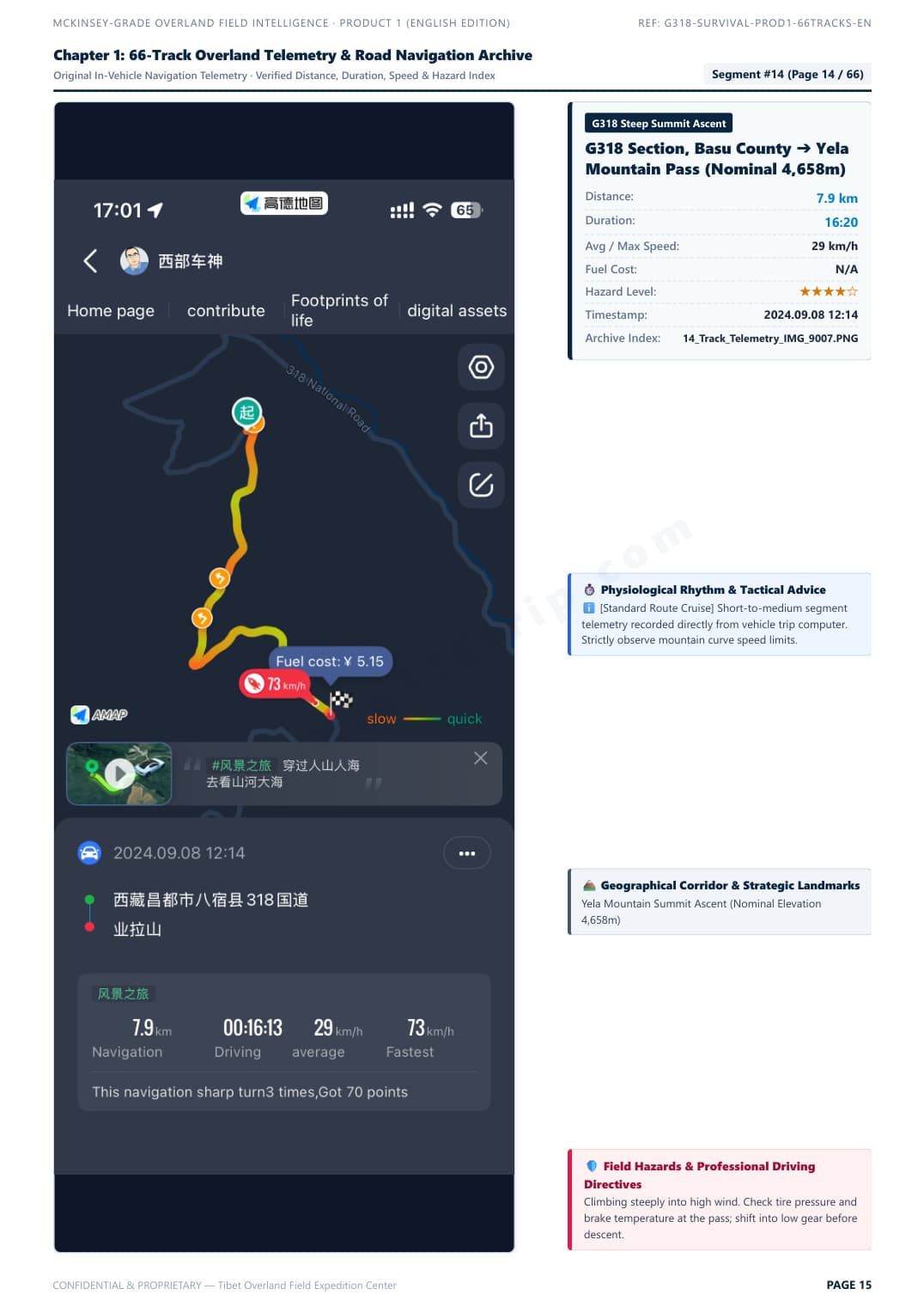
Telemetry Track & Blind Curve Protocol
Segment #15: Zheduo Pass ➔ Xinduqiao. Real in-vehicle telemetry with elevation curve, average speed, and overtaking tactics.
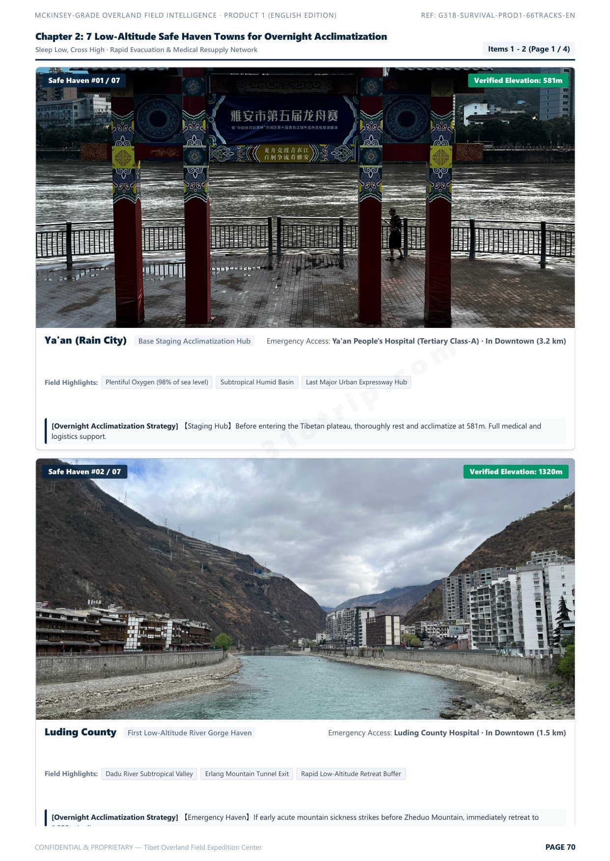
7 Low-Altitude Safe Haven Towns
Scientific hypoxia staging strategy: sleep low, climb high. Safe night stop elevations and rapid emergency descent corridors.
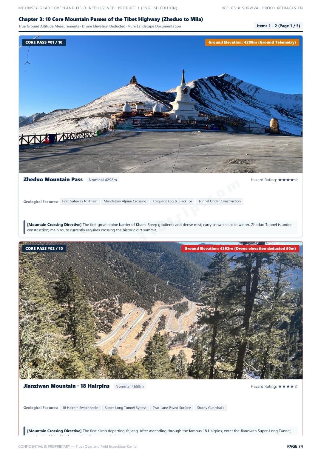
10 Core Mountain Passes Clearance Guide
Zheduo, Haizi, Dongda, Mila passes. Real gradients, road surface conditions, and vehicle chassis clearance ratings.
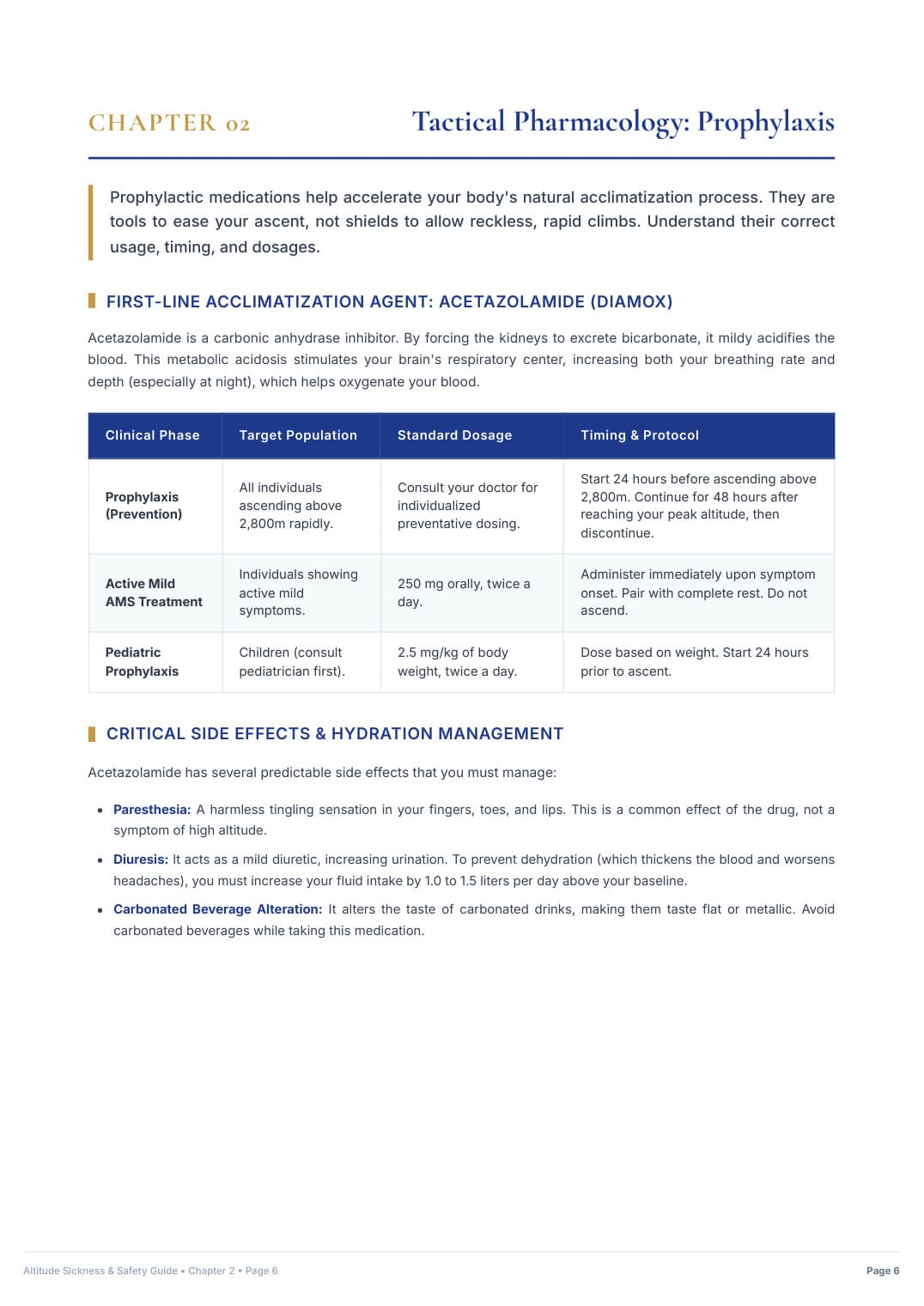
Hospital-Grade AMS Clinical Protocol
25-page acute mountain sickness emergency protocol, S.O.A.D. rapid descent workflow, and prescription medication matrix.
G318 Overland Survival & Road Field Manual
The definitive self-drive road intelligence blueprint. Solves chassis clearance hazards, certified low-elevation sleep staging, and clinical acute mountain sickness protocols.
Instant Single-File PDF Delivery (91 MB) · Standalone Survival Manual
G318 Master 100 Drone & Photo Waypoints Pack
Dedicated visual takeoff archive. 100 curated spots with verified DJI EXIF coordinates, true ground elevations, golden-hour lighting windows, and universal offline map files.
Instant Digital Download (~24 MB): 52-Page Master PDF + KML Waypoints + Excel Sheet
G318 Ultimate Overland & Creator Bundle
The all-in-one expedition master suite. Combines Product 1 (66 Telemetry Tracks Road Survival Manual) AND Product 2 (100 Verified Drone Waypoints Archive, Universal KML Maps & Master Excel Sheet) at a discounted package price.
G318 Elevation & Altitude Acclimatization FAQ
Direct, factual answers to essential elevation queries searched by international travelers planning their Sichuan-Tibet overland journeys in 2026.
Don't Travel 2,142km into the Himalayas Unprepared
Get instant offline access to the G318 Field Dossiers: kilometer-by-kilometer sleeping altitude guide, 66 in-vehicle telemetry tracks, bilingual emergency flashcards, and optional 100 drone waypoints with offline KML file.