The Alps of the East · 2026 Field Guide

Mount Siguniang Hiking & 3 Valleys Guide

Your ultimate logistical blueprint to Western Sichuan’s Four Sisters Mountain: comprehensive head-to-head comparisons of Shuangqiao, Changping, and Haizi Valleys, beginner 5,025m Dafeng climbing routes, official outdoor permits, and high-altitude acclimatization strategy.

Compare The 3 Valleys Dafeng 5,025m Climb Recommended Routes
4 Peaks
5,025m to 6,250m
Zero Tibet Permit
Open to all foreign passports
3.5 Hours
Drive from Chengdu (220km)
May – Nov
Prime trekking season
Dramatic snow-draped peak of Mount Siguniang rising above alpine meadows in Western Sichuan
Live 2026 National Park & Route StatusShuangqiao, Changping & Haizi Open Year-Round
At A Glance

Why Mount Siguniang Belongs on Your China Itinerary

Often referred to by global mountaineers as the "Alps of the East" (东方的阿尔卑斯), Mount Siguniang National Park encompasses four dramatic snow peaks rising majestically above the Jiarong Tibetan valleys.

Rapid Access from Chengdu

Only 220 km west of Chengdu. Following the completion of the 8km Balang Mountain Tunnel, travel time has dropped to just 3.5 hours on well-paved expressway, making it the most accessible glaciated alpine playground in western China.

Diverse Skill Tiers

Whether you prefer wheelchair-accessible timber boardwalks and heated sightseeing buses (Shuangqiao), scenic horseback trails (Changping), or summiting an actual 5,000m peak on foot (Dafeng in Haizi), the park caters to every endurance level.

Zero Tibet Permit Restrictions

Unlike the Tibet Autonomous Region (TAR), Mount Siguniang is nestled in Sichuan Province. Foreign independent travelers can visit freely with standard Chinese tourist visas, zero mandatory group tour requirements, and total itinerary flexibility.

The Essential Dilemma

Which Valley Should You Choose? Head-to-Head Comparison

Mount Siguniang consists of three distinct, non-connecting parallel valleys. You cannot walk between them inside the park; each requires separate tickets and entry gates. Here is how they compare:

Easy / Family · Difficulty: ★☆☆☆☆

Shuangqiao Valley 双桥沟 (Twin Bridges)

The Effortless Scenic Jewel — 100% Shuttle Accessible
Admission
¥80 CNY (Peak: Apr 1 – Nov 30) / ¥50 CNY (Off-peak)
Shuttle Fee
¥70 CNY (Mandatory roundtrip)
Elevation
3,200m – 3,840m (10,500ft – 12,600ft)

The most commercially developed and visually accessible valley in the national park. Modern eco-shuttles climb to the end of the valley (Redwood Forest at 3,840m), allowing you to stroll downhill along timber boardwalks flanked by towering snow peaks, sea buckthorn groves, and crystalline glacial streams.

Top Sights & Key Milestones

Redwood Forest (红杉林)3,840m

Terminal shuttle turnaround surrounded on three sides by sheer 5,000m serrated granite pyramids.

Potala Peak Viewing Deck (布达拉峰)3,650m

A colossal granite monolith resembling Lhasa's Potala Palace. Popular road-leading-to-peaks photo spot.

Four Sisters Lake (四姑娜措)3,580m

Serene alpine reflection pool studded with petrified tree trunks mirroring snowy summits.

Sea Buckthorn Forest (撵鱼坝)3,500m

Centuries-old thorny buckthorn trees alongside rushing turquoise rapids. Rafting available in summer.

Ideal For:
  • First-time visitors & families with children/seniors
  • Landscape & portrait photographers seeking effortless framing
  • Winter ice-climbers (over 100 frozen waterfall routes)
  • Travelers needing gentle altitude acclimatization on Day 1
Local Ranger Insider Tip:

Take the shuttle directly to the highest point (Redwood Forest 3,840m) first thing in the morning. Then spend your day walking downhill along the wooden boardwalks between stations. You'll avoid peak crowds and breathe comfortably while descending.

The 4 Sacred Peaks

From Gentle 5,000m Trekking to Queen of Sichuan

Legend tells of four beautiful Tibetan sisters who transformed into towering snow peaks to protect giant pandas and sacred valleys from demons. Each daughter possesses a distinct mountaineering personality:

大峰Non-Technical / Grade I

Dafeng (1st Daughter Peak)

5,025 m (16,486 ft)

China's most famous beginner-friendly 5,000-meter trekking peak. Mild scree and rocky trail leading to a razor summit ridge.

Required: Solid cardiovascular fitness, high-altitude endurance, basic walking with trekking poles. No ropes or technical crampons required in warm months.
二峰Challenging Trek / Semi-Scramble

Erfeng (2nd Daughter Peak)

5,276 m (17,310 ft)

Slightly steeper and more sustained than Dafeng. Involves hands-on rock scrambling near summit and an exposed 300m summit ridge.

Required: Scrambling comfort, head for heights on narrow ridges. Microspikes or crampons required after seasonal snowfalls.
三峰Technical Alpine / Grade II-III

Sanfeng (3rd Daughter Peak)

5,355 m (17,569 ft)

A steep, rugged pyramid requiring roped alpine climbing, fixed rope ascents (jumaring), and rappelling over rock and mixed ice bands.

Required: Harness, helmet, figure-8 rappel, jumar handling, crampon self-arrest. Prior rock climbing and high-altitude experience mandatory.
幺妹峰 (Queen of Sichuan)Extreme Alpine / Grade V-VI

Yaomei (The Youngest Sister)

6,250 m (20,505 ft)

The holy mountain of Tibetan mythology and second highest peak in Sichuan. A daunting, sheer granite fang dubbed 'The Alps of the East'.

Required: Elite international mountaineering standard only. Has claimed numerous expert lives; fewer than 50 people have successfully summitted.

Dafeng (5,025m) Beginner Climbing Expedition Blueprint

China's premier entry point for high-altitude non-technical summit mountaineering
Stage 1: Basecamp Trek (3,200m → 4,379m)

Starting from Haizi Valley gate, hike 15 km along grassy ridgelines past Guozhuangping. You gain ~1,180 vertical meters over 5–7 hours. Horses are available to carry heavy expedition duffels or assist fatigued hikers. Night is spent in rustic stone bunkhouses or private four-season tents at Basecamp.

Stage 2: Midnight Alpine Push (4,379m → 5,025m)

Wake-up call at 03:00 AM with headlamps. The trail ascends steady switchbacks across scree slopes to the pass, followed by a fortified timber handrail path along the dramatic summit ridge. You reach the 5,025m summit marker by sunrise (approx. 06:45–07:30 AM) with breathtaking views of Mt. Yaomei.

Stage 3: Rapid Safe Descent

Descent from the summit back to Basecamp takes 2 to 2.5 hours. After hot soup and noodle recharge, descend the remaining 15km back to Siguniang Town, arriving by mid-afternoon (or hire a horse down if knees are strained). Celebrate with authentic Tibetan hotpot!

Curated Route Options

Recommended Mount Siguniang Travel Itineraries

Whether you have 48 hours for a quick mountain escape from Chengdu or four days for an unforgettable high-altitude summit, here are three battle-tested routes:

Recommended Standard

3-Day Classic In-Depth Experience

The perfect balance of scenic comfort and moderate day-hiking right beneath Mt. Yaomei
Day 1
Chengdu → Wolong Panda Center → Siguniang Town

Depart Chengdu and stop at Wolong Shenshuping Panda Base to see giant pandas in their native bamboo habitat. Cross Balang Tunnel (3,800m) and reach Siguniang Town. Night in hotel with oxygen concentrators.

Day 2
Full Day in Shuangqiao Valley (Photo Safari)

Immerse in the dramatic photography spots of Shuangqiao Valley. Walk the scenic 5km trail between Potala Peak and Nuorilang waterfall without rushing. Sunset photo shoot at Maobiliang vantage point.

Day 3
Changping Valley Trek to Muliangtai → Return to Chengdu

Enter Changping Valley. Walk the pine boardwalk from Lama Temple to Kushutan, continuing along the dirt trail to Muliangtai (3,670m) directly underneath the titanic south wall of Mt. Yaomei. Return to town by 14:30 PM and drive back to Chengdu.

Official Safety Compliance

Outdoor Center Regulations, Permits & Standardized Fees

Mount Siguniang is managed by strict safety and environmental standards. While day-visitors to Shuangqiao and Changping valleys only require ordinary entrance tickets, all backcountry trekking and climbing must comply with official park protocols:

Mandatory Real-Name Outdoor Registration

For any multi-day camping, high-altitude trekking, or summit climbing in Haizi Valley or Changping Valley, you must register in person at the Mount Siguniang Outdoor Sports Management Center (四姑娘山户外运动管理中心). Unregistered backcountry hiking is strictly illegal and subject to heavy fines.

Licensed Mountain Guide Ratios

Official safety regulations stipulate a strict maximum guide-to-client ratio: 1 certified local guide for every 3 climbers on Dafeng/Erfeng, and 1:2 on technical Sanfeng. Guides must hold valid Sichuan Mountaineering Association credentials.

Outdoor Conservation Fee & Trash Deposit

Trekking and climbing permits require an outdoor fee of ¥150 CNY per person (valid for 3 days), plus a refundable environmental deposit of ¥200 CNY returned upon bringing your trash back to the registration office.

Standardized Horse & Porter Tariffs

To prevent predatory tourist pricing, the local Tibetan Horse Management Cooperative enforces fixed official rates: approx. ¥320–¥360 CNY per horse per day for Changping/Haizi valleys (including horseman). Tips are voluntary.

Acclimatization Strategy

Chengdu (500m) to Siguniang Town (3,200m) Elevation Gain

In just 3.5 hours, you transition from the humid Chengdu basin (500m) to a high-altitude alpine plateau. Proper pacing and acclimatization on your first 24 hours ensures a headache-free journey:

STARTING POINT
Chengdu (成都)
500 m / 1,640 ft · 100% Oxygen
HIGHEST HIGHWAY POINT
Balang Tunnel (巴朗山隧道)
3,800 m / 12,460 ft · Tunnel bypasses old 4,480m pass
BASE TOWN
Siguniang Town (日隆镇)
3,200 m / 10,500 ft · 69% Oxygen
✓ The 3 Golden Rules for First-Day Comfort in Siguniang Town:
  • No Hot Showers on Night 1: Hot showers dilate peripheral blood vessels, temporarily reducing cerebral blood flow and triggering nocturnal altitude headaches.
  • Hydrate with Electrolytes: The alpine air is exceptionally dry. Consume 3–4 liters of fluids per day (warm water, ginger tea, or oral rehydration salts).
  • Visit Shuangqiao Valley on Day 1: The shuttle bus does the heavy climbing for you, allowing your cardiovascular system to gently adapt before attempting the foot trails of Changping or Haizi.
100% Customized Western Sichuan Expeditions

Plan Your Private Mount Siguniang Trekking Tour

Experience Mount Siguniang with private 4WD transport directly from your Chengdu hotel, bilingual certified trekking guides, registered mountain permits, high-altitude medical safety gear, and handpicked boutique Tibetan lodges.

Request Private Custom Itinerary ✓ Tailored for solo hikers, couples, or private family groups
Common Questions

Mount Siguniang Travel & Trekking FAQ

Practical answers to the most common traveler queries regarding logistics, fitness, and valley selection.

If you want effortless sightseeing, guaranteed mountain views, and gentle walks suitable for any fitness level, choose Shuangqiao Valley (双桥沟). The mandatory shuttle takes you right to the foot of glaciated peaks at 3,840m, requiring minimal exertion. However, if your primary dream is to stand face-to-face with Mt. Yaomei (6,250m) and you enjoy active 5–7 hour day-hiking on forest boardwalks, choose Changping Valley (长坪沟).

Ready to Trek the Sacred Sisters?

Combine Mount Siguniang with Western Sichuan & G318

Mount Siguniang is the ultimate first gateway on any Western Sichuan loop, perfectly linking Danba Tibetan villages, Tagong grassland, and National Highway 318.
Explore Western Sichuan Circuit ✓ Zero Permit Needed · High Alpine Glaciers & Tibetan Culture
2026/2027 Verified Field Intelligence Dossiers

Look Inside Before You Decide

Tested across 5,144 physical survey assets. Zero generic fluff. Inspect authentic sample pages from both dossiers below, then choose your digital expedition pack.

Product 1 · Self-Drive Safety & Medical Blueprint

G318 Overland Survival & Road Field Manual (104 Pages)

Inspect authentic interior pages: real in-vehicle telemetry logs, low-altitude safe havens, high mountain pass profiles, and clinical AMS protocols.

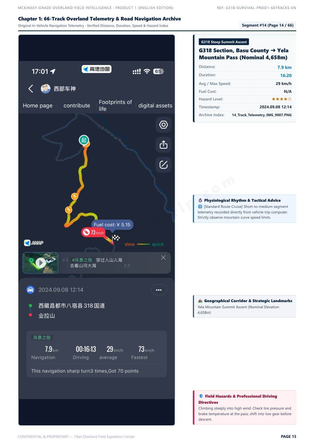
Telemetry Track & Blind Curve Protocol
Field Survey Baseline: Autumn 2024 · 2026/2027 Road Status Verified
Click to Enlarge Page

Telemetry Track & Blind Curve Protocol

Segment #15: Zheduo Pass ➔ Xinduqiao. Real in-vehicle telemetry with elevation curve, average speed, and overtaking tactics.

Verified Raw DossierZoom
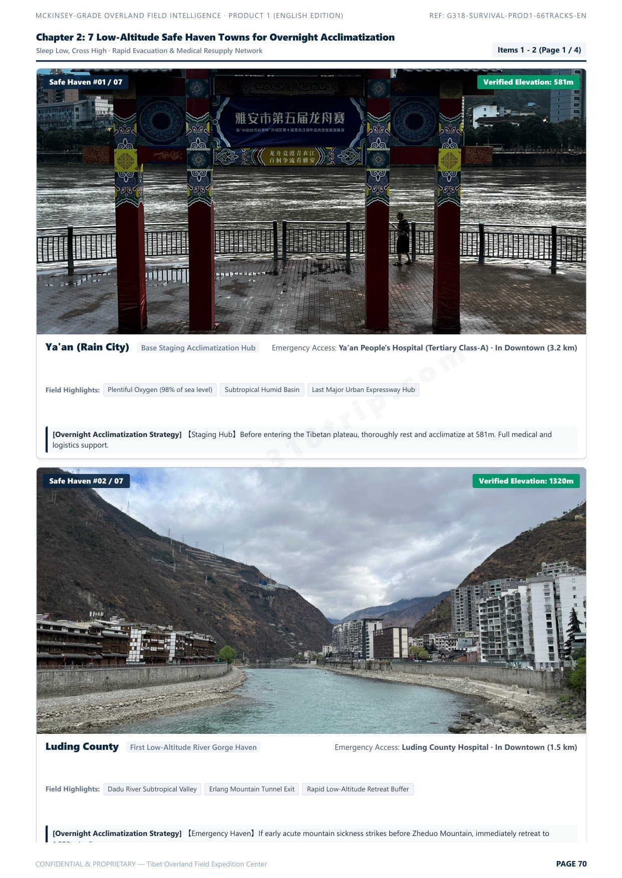
7 Low-Altitude Safe Haven Towns
Clinical Acclimatization Map
Click to Enlarge Page

7 Low-Altitude Safe Haven Towns

Scientific hypoxia staging strategy: sleep low, climb high. Safe night stop elevations and rapid emergency descent corridors.

Verified Raw DossierZoom
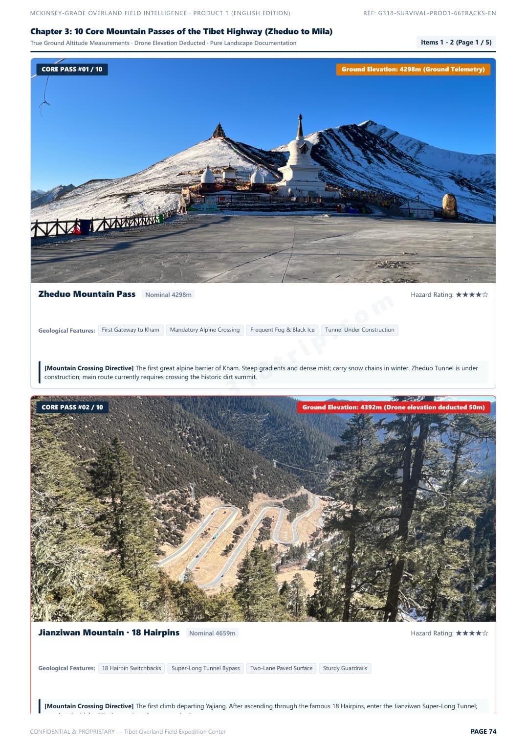
10 Core Mountain Passes Clearance Guide
Pass Bottleneck Profiles
Click to Enlarge Page

10 Core Mountain Passes Clearance Guide

Zheduo, Haizi, Dongda, Mila passes. Real gradients, road surface conditions, and vehicle chassis clearance ratings.

Verified Raw DossierZoom
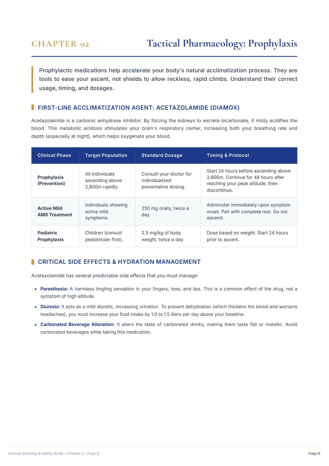
Hospital-Grade AMS Clinical Protocol
Emergency Medical Directive
Click to Enlarge Page

Hospital-Grade AMS Clinical Protocol

25-page acute mountain sickness emergency protocol, S.O.A.D. rapid descent workflow, and prescription medication matrix.

Verified Raw DossierZoom
↓ Choose Your Complete Uncensored Digital Pack Below ↓
Product 1 · Self-Drive Safety & Road Pass Dossier

G318 Overland Survival & Road Field Manual

The definitive self-drive road intelligence blueprint. Solves chassis clearance hazards, certified low-elevation sleep staging, and clinical acute mountain sickness protocols.

$39.90USD · Standalone Edition
Detailed Inclusions & Rights (全部实测权益):
66 Verified In-Vehicle Telemetry Tracks: Chengdu ➔ G318 South ➔ Lhasa ➔ Yamdrok Loop ➔ G317 North ➔ Chengdu Return Loop
10 Core Mountain Passes with Real Gradients & Clearance Ratings (Zheduo, Haizi, Dongda, Mila, etc.)
7 Golden Low-Altitude Overnight Sleep Havens (Safe Hypoxia Staging at Batang, Bomi, Nyingchi & more)
Mountain Road Blind Curves & Heavy Truck Overtaking Survival Rules (Break out of multi-mile slow convoys)
8 Severe Geohazard Blackspots (Active rockfalls, mudslides, riverbed washouts & black ice traps)
25-Page Hospital-Grade Acute Mountain Sickness (AMS) Clinical Protocol & Prescription Drug Matrix
Bilingual Medical & Police Emergency Flashcards (English & Chinese with phonetic pinyin)
100% Offline Access: High-Definition Mobile PDF (Zero cell signal needed on mountain passes)

Instant Single-File PDF Delivery (91 MB) · Standalone Survival Manual

Product 2 · Creators & Aerial Takeoff Archive

G318 Master 100 Drone & Photo Waypoints Pack

Dedicated visual takeoff archive. 100 curated spots with verified DJI EXIF coordinates, true ground elevations, golden-hour lighting windows, and universal offline map files.

$79.90USD · Standalone Edition
Detailed Inclusions & Rights (全部实测权益):
100 Curated Drone & Camera Master Waypoints (5 Thematic Chapters: Holy Mountains, Glaciers, Passes, Lakes, Kham Culture)
Extracted from Real DJI Drone EXIF Flight Data with Dual WGS-84 (Garmin/Google Earth) & GCJ-02 (Amap/Ovital) Coordinates
True Ground Elevations (Strictly Subtracted Drone Takeoff Altitudes for Precise Real-World Planning)
Universal Offline Map Pack: Ready-to-import KML files for Ovital Map, Amap (高德), and Google Earth + Excel/CSV Master Sheet
Calculated Golden Hour Lighting Windows & Sun Angles for Glaciers, Mountain Passes & Canyon Gorges
Pass-Specific & Canyon Safe Takeoff Protocols, Compass Calibration Rules & Gale-Force Wind Warnings
52-Page High-Res Illustrated English Drone Master Dossier (Full 100 Takeoff Spots with Visuals)
Instant Digital Delivery Archive (~24 MB): Illustrated PDF + Universal KML + Master Excel Sheet

Instant Digital Download (~24 MB): 52-Page Master PDF + KML Waypoints + Excel Sheet

👑 COMPLETE EXPEDITION PACKAGE · THE DEFINITIVE CREATOR BUNDLE
Best Value Deal · Save $19.90 USD

G318 Ultimate Overland & Creator Bundle

The all-in-one expedition master suite. Combines Product 1 (66 Telemetry Tracks Road Survival Manual) AND Product 2 (100 Verified Drone Waypoints Archive, Universal KML Maps & Master Excel Sheet) at a discounted package price.

$119.80$99.90USD · Full Bundle
Instant delivery of all PDF manuals, KML map files & photo archives
Everything Included in This Master Bundle (包含全部两大产品权益):
✓ INCLUDES COMPLETE PRODUCT 1: G318 Overland Survival & Road Field Manual ($39.90 Standalone Value)
✓ INCLUDES COMPLETE PRODUCT 2: Master 100 Drone & Photo Waypoints Pack ($79.90 Standalone Value)
66 Verified In-Vehicle Telemetry Tracks (Full Loop: Chengdu ➔ G318 ➔ Lhasa ➔ Yamdrok ➔ G317 ➔ Chengdu)
100 Verified Drone Takeoff Spots with Real DJI EXIF Coordinates & True Ground Elevations
Universal Offline KML & CSV Navigation Packs (Ready to import to Ovital Map, Amap, Google Earth & Garmin)
10 High-Altitude Passes with Elevation Profiles, Clearance Ratings & True Gradients
7 Golden Low-Altitude Overnight Sleep Havens (Safe Hypoxia Staging at Batang, Bomi, Nyingchi, etc.)
Mountain Road Blind Curves & Heavy Truck Overtaking Tactics (Break out of multi-mile convoys)
8 Severe Geohazard Blackspots (Landslides, debris flows, riverbed washouts & freeze-thaw ice traps)
25-Page Hospital-Grade Acute Mountain Sickness (AMS) Clinical Acclimatization & Rx Drug Protocol
Calculated Golden Hour Lighting Windows & Sun Angles for Glaciers, Mountain Passes & Canyon Gorges
Pass & Canyon Safe Takeoff Protocols, Compass Calibration Rules & Gale Wind Warnings
Bilingual Medical & Police Emergency Flashcards (English & Chinese with phonetic pinyin)
Instant Digital Delivery Archive (~40 MB Total): Illustrated PDFs + Universal KML + Master Excel Sheets
Unlock Complete 2027 Overland & Drone Master Package
Single-click payment via Stripe with immediate authenticated download link generated.
256-Bit Encrypted Stripe Checkout100% Offline Access · No Cell Signal NeededSupports Apple Pay, Google Pay, Visa & Amex