Field Telemetry Benchmark · 65 Consecutive Segments

G318 vs G317 Highway Conditions: 65-Segment Field Telemetry, Mountain Passes & Real Driving Speeds

The definitive road reality report for international travelers and overland drivers. Based on continuous onboard GNSS vehicle logs across the entire Sichuan-Tibet loop (G318 South in, G109 Nagqu connector, G317 North out): verified tarmac coverage, actual average speeds, mountain pass altitudes, cellular dead zones, and 8 critical landslide hazard zones.

View 65-Segment Speeds 8 Geological Hazard Hotspots G318 vs G317 Architecture
65
Consecutive GNSS runs
Only 3
G5, Linla & Wenma expressways
5,130 m
Dongda Mountain Pass (G318)
43 Bends
Gamba La Pass (-1,410m vert)
Verified Ground Truth

Western travel forums often oscillate between two extremes: claiming G318 is an impassable mud pit, or claiming it is an easy expressway. Our 65-segment telemetry log establishes the verified truth: 100% of G318 is modern asphalt, yet it remains a technical alpine mountain highway with 14 passes above 4,000 meters.

Only 3 True Expressways

Across the entire 2,200 km loop, multi-lane divided expressways exist only between Chengdu and Ya'an (G5), Nyingchi and Lhasa (Linla Highway), and Barkam and Chengdu. All other stretches are two-lane switchbacks.

Route Comparison

G318 Southern Route vs G317 Northern Route: Core Differences

While both routes traverse western China from Chengdu into Tibet, their geographic character, infrastructure maturity, and driving challenges differ significantly:

DimensionG318 Sichuan-Tibet SouthG317 Sichuan-Tibet North
Route CharacterScenic landscape corridor: alpine forests, glacial lakes, snow mountains, vibrant towns.Cultural & wilderness corridor: ancient Bon/Buddhist monasteries, raw nomad tundra, remote valleys.
Pavement Status100% Paved Asphalt (Full trunk)95% Paved; occasional gravel branches (Zhizhu, Bujia)
Average ElevationGradual staircase climb (2,500m to 4,000m)Sustained high altitude (Nagqu-Baqen-Dingqing ~4,200m+)
Traffic VolumeHeavy tourist traffic + supply semi-trucks; frequent overtaking required.Sparse tourist traffic; local trucks and livestock crossings.
Emergency FacilitiesAbundant oxygen supplies & hospitals in Kangding, Litang, Bomi, Nyingchi.Fewer specialized clinics; Nagqu & Chamdo serve as primary hubs.
Onboard GNSS Logs

Real Driving Speeds: Verified 65-Segment Field Telemetry

Representative runs extracted from our continuous 65-segment telemetry recording. Notice the stark contrast between expressway corridors (70+ km/h) and technical descents like the Nujiang 72 Hairpin Turns (21 km/h average):

#01

Chengdu ➔ Ya'an (G5 Expressway)

Sichuan Basin transition corridor
133.7 km1h 48m73 km/h (Max 125)Low Risk
Field Observation: Smooth tollway transition from Chengdu plain to rain-belt Ya'an.
#03

Kangding ➔ Xinduqiao (Zheduo Pass)

Alpine mountain ascent to 4,298m
40.9 km50m 49s48 km/h (Max 91)Medium Risk
Field Observation: First major barrier pass; sudden icy flurries and heavy oxygen drop.
#10

Batang ➔ Haitonggou ➔ Mangkang

Jinsha River fault line & Lawu Pass (4,376m)
100.6 km3h 14m31 km/h (18 hairpin turns)High Risk
Field Observation: Haitonggou gorge is highly prone to active mudslides & rockfall during summer rains.
#11

Mangkang ➔ Dongda Pass ➔ Zuogong

Dongda Mountain Pass (5,130m)
139.3 km5h 21m26 km/h (Max 88)High Risk
Field Observation: Highest highway pass on southern G318. Freezing gale winds and sub-zero temperatures.
#15

Yela Pass ➔ 72 Turns ➔ Baxoi

Salween River (Nujiang) steep canyon
24.3 km1h 09m21 km/h (Continuous descent)Extreme Risk
Field Observation: World-famous 72 Hairpin Turns. Heavy truck brake wear; strict speed management essential.
#23

Bomi ➔ Tongmai ➔ Lulang

Parlung Tsangpo Canyon (Tongmai)
149.7 km3h 02m49 km/h (Modern tunnels)Low-Medium Risk
Field Observation: Former 'Tongmai Graveyard' now completely bypassed by modern 5-tunnel & mega-bridge system.
#27

Nyingchi ➔ Mila Tunnel ➔ Lhasa

Mila Tunnel (5,727m long at 4,752m altitude)
250.4 km3h 30m71 km/h (Max 120)Low Risk
Field Observation: Ultra-modern toll-free high-grade highway into holy city Lhasa.
#43

Nagarze ➔ Gamba La Pass ➔ Quxu

Vertical drop from 4,990m to 3,580m (-1,410m)
50.4 km1h 03m47 km/h (43 sharp hairpin turns)Extreme Risk
Field Observation: Overlooking Yamdrok Lake; 43 switchback turns requiring continuous downshifting.
#54

Dingqing ➔ Zhizhu Temple Hanging Road

Cliff face shelf road ascending to 4,800m
33.7 km55m 20s36 km/h (Cliffside gravel)Extreme Risk
Field Observation: Sheer vertical drop on unpaved ledge; strictly reserved for experienced 4WD high-clearance rigs.
Safety Assessment

8 Active Geological & Driving Hazard Hotspots

Despite complete asphalt paving, the Himalayan tectonic fracture belts produce active landslides, rockfalls, and flash-freezes. Here are the 8 critical sectors to navigate with heightened discipline:

G318 Sichuan-Tibet border (Batang to Mangkang)High Hazard

Haitonggou Gorge (海通沟)

Active tectonic fault line with frequent mudslides and loose scree falls after downpours.

Countermeasure: Inspect local highway police updates before departure. Do not linger under steep overhangs.
G318 Yela Mountain descent to Salween RiverBrake Failure Zone

Nujiang 72 Hairpin Turns (怒江72拐)

Continuous 1,500-meter drop across 24 kilometers with constant hairpin switchbacks.

Countermeasure: Shift into low gear (manual mode 2/3) for engine braking. Do not ride foot brakes continuously.
S307 Lake Yamdrok to Quxu ValleySevere Downhill

Gamba La Cliffside Descent (岗巴拉山陡降)

43 severe switchback bends with a 1,410m vertical drop; narrow shoulder edges overlooking steep ravines.

Countermeasure: Sound the horn before blind turns. Yield right-of-way to ascending commercial buses and tour coaches.
G318 Parlung Tsangpo CanyonSeasonal Flash Floods

Bomi to Tongmai Gorge (波密松宗至通麦)

Glacial meltwater surges and monsoon rains trigger roadside ditch flooding and occasional rock rolls.

Countermeasure: Drive during early morning hours; avoid night driving through wet forested canyon channels.
G317 Dingqing County (Northern Route)Unpaved Shelf Road

Zhizhu Temple Cliff Track (孜珠寺绝壁天路)

Narrow, unpaved gravel track hugging precipitous cliffs climbing to 4,800m altitude without guardrails.

Countermeasure: Only drive in dry conditions with high-clearance AWD/4WD. Avoid immediately after rain or snow.
Suxian to Puyuk GlacierOff-Road Terrain

Bujia Glacier Pastoral Track (布加雪山牧道)

Raw unpaved highland gravel and riverbed tracks across fragile permafrost tundra.

Countermeasure: Carry tire inflation kit, tow strap, and satellite communicator. Never venture solo in heavy snow.
G109 Dangxiong to Nagqu (Altitude 4,500m+)Sub-surface Subsidence

North Tibet Permafrost Wave Road (藏北冻土波浪路)

Thawing permafrost causes asphalt undulations, sudden dips, and violent potholes under heavy truck wear.

Countermeasure: Keep speed strictly below 70 km/h; sudden bottoming-out can crack oil pans or trigger rollovers.
G318 Elevation > 4,200mBlack Ice & Blizzards

Zheduo & Dongda Mountain Pass Blizzards

Rapid weather changes from clear blue skies to gale-force snow squalls within 20 minutes.

Countermeasure: Carry snow chains between October and May. Check tire tread depth before ascending.
Why Maps Draw "Straight Lines" Across Mountain Canyons

When analyzing GPS or mapping screen captures along G318/G317, travelers frequently spot straight, unswerving vectors cutting 10–20 km through impassable granite massifs. These are not direct bridges or flight highways. They represent cellular base-station blackouts:

Canyon Signal Loss: In deeply cut gorges like the Nujiang Canyon and Tongmai, cellular towers cannot penetrate sheer granite walls. Systems switch to offline GPS dead-reckoning.
Ignition Shutdown Vectors: If a vehicle idles at a viewpoint or halts for road repair for over an hour, car navigation powers down. Upon restart, the software connects the last shutdown point with the new satellite fix via a straight line.
Driver Survival Rules

Blind Curve Honking & Overtaking Heavy Truck Convoys

Along high-altitude two-lane passes, commercial 40-ton semi-trucks haul essential timber, cement, and food into Lhasa. Being stuck behind a slow convoy for 15 km is a frequent reality. Overtaking safely requires mastery of local highway communication etiquette:

The Blind Corner Double-Honk

When approaching a blind switchback wrapped around a cliff face, tap your horn twice firmly during daylight. At night, alternate high and low beams twice to alert oncoming descent traffic.

Deciphering Truck Turn Signals

Veteran plateau truck drivers frequently use their turn signals to assist following cars. If a truck activates its right turn signal on an uphill straight, the driver is signalling that the road ahead is clear to pass. Never overtake if they signal left.

Engine Braking vs Disc Overheating

Descending the Gamba La (-1,410m) or 72 Turns solely by foot braking causes brake fluid boiling within 15 minutes. Always downshift to gear 2 or 3 to let engine compression control vehicle speed.

Essential Clarifications

Frequently Asked Questions on G318 & G317 Highway Conditions

Yes. The main trunk of the G318 Southern Route from Chengdu to Lhasa is 100% paved with modern asphalt. Bottlenecks like Erlang Mountain, Jianziwan, Tuoluolaka, and Tongmai are now connected via modern tunnels and bridges. However, occasional landslide repairs or seasonal road maintenance can introduce brief gravel detours.

Planning Your Own G318 Overland Journey?

Navigating high-altitude passes, permit regulations, and reliable vehicles requires seasoned coordination. Explore our vetted private itineraries with licensed local commercial drivers and transparent quotes.
Explore 12-Day Chengdu to Lhasa Route Foreign Driving Permit Guide
2026/2027 Verified Field Intelligence Dossiers

Look Inside Before You Decide

Tested across 5,144 physical survey assets. Zero generic fluff. Inspect authentic sample pages from both dossiers below, then choose your digital expedition pack.

Product 1 · Self-Drive Safety & Medical Blueprint

G318 Overland Survival & Road Field Manual (104 Pages)

Inspect authentic interior pages: real in-vehicle telemetry logs, low-altitude safe havens, high mountain pass profiles, and clinical AMS protocols.

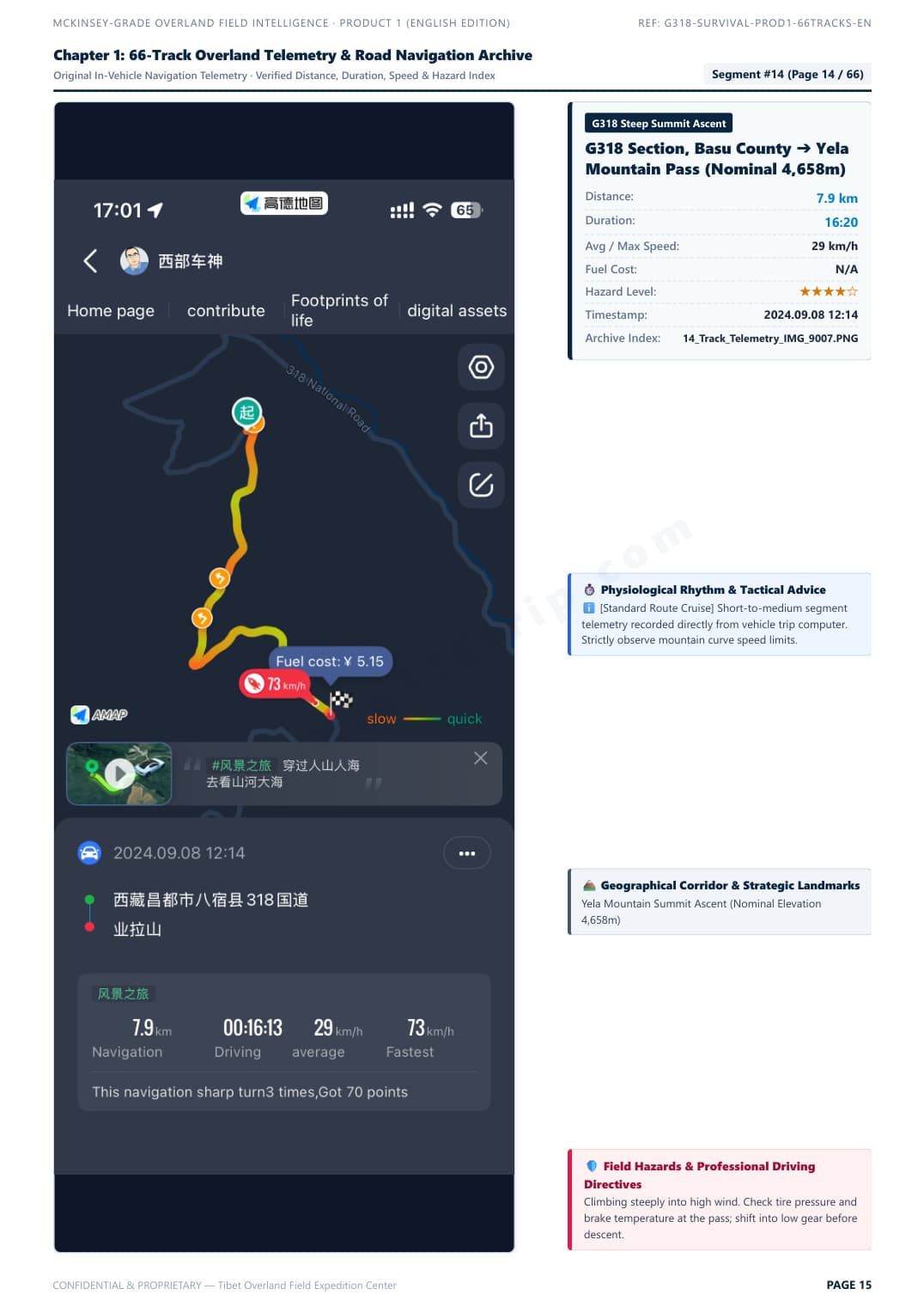
Telemetry Track & Blind Curve Protocol
Field Survey Baseline: Autumn 2024 · 2026/2027 Road Status Verified
Click to Enlarge Page

Telemetry Track & Blind Curve Protocol

Segment #15: Zheduo Pass ➔ Xinduqiao. Real in-vehicle telemetry with elevation curve, average speed, and overtaking tactics.

Verified Raw DossierZoom
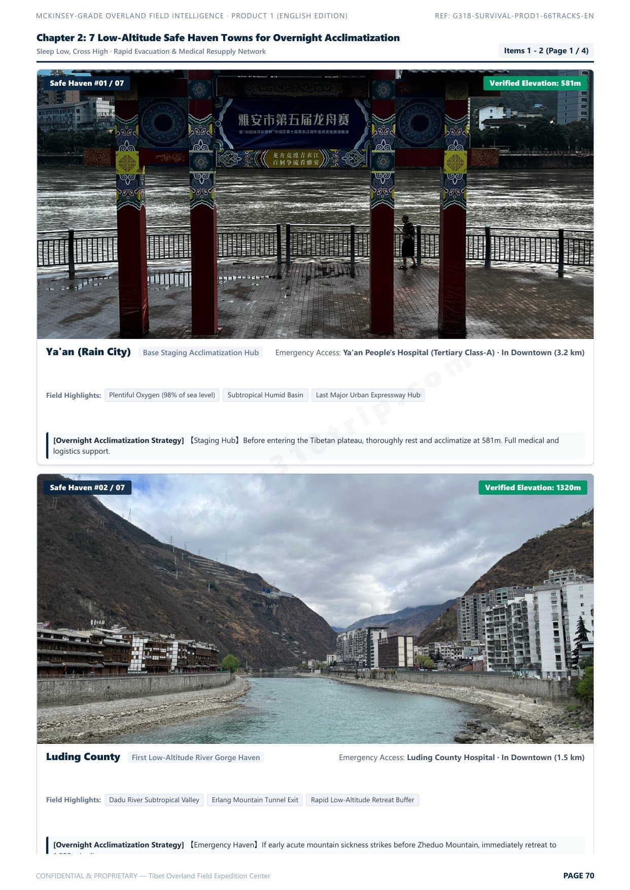
7 Low-Altitude Safe Haven Towns
Clinical Acclimatization Map
Click to Enlarge Page

7 Low-Altitude Safe Haven Towns

Scientific hypoxia staging strategy: sleep low, climb high. Safe night stop elevations and rapid emergency descent corridors.

Verified Raw DossierZoom
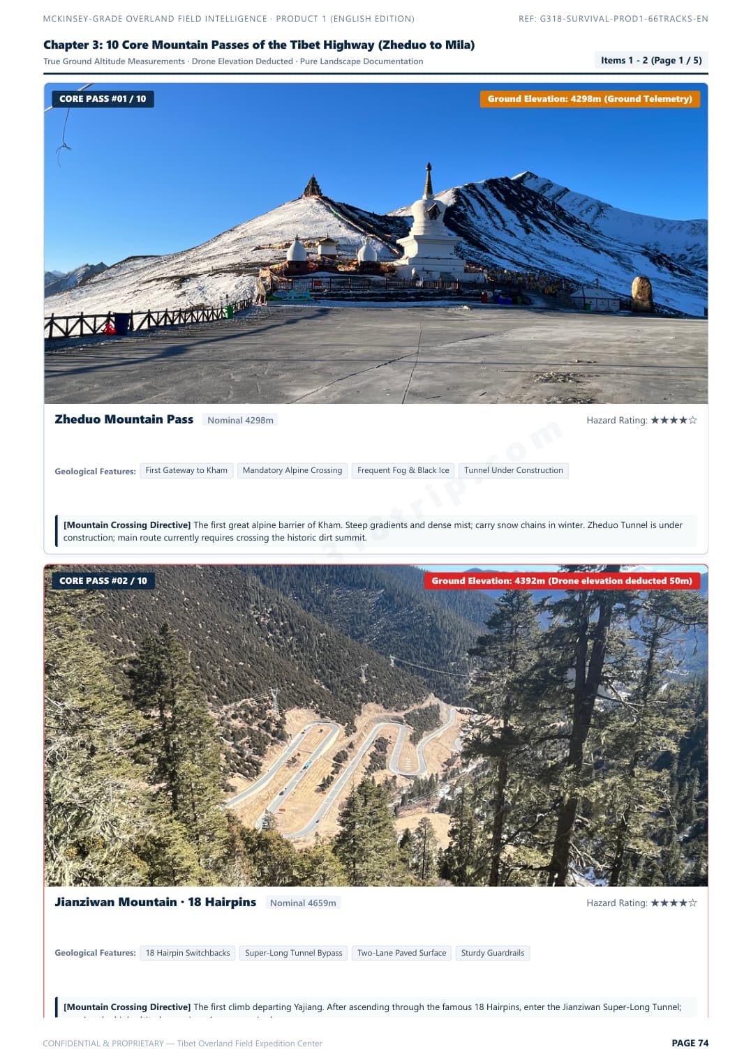
10 Core Mountain Passes Clearance Guide
Pass Bottleneck Profiles
Click to Enlarge Page

10 Core Mountain Passes Clearance Guide

Zheduo, Haizi, Dongda, Mila passes. Real gradients, road surface conditions, and vehicle chassis clearance ratings.

Verified Raw DossierZoom
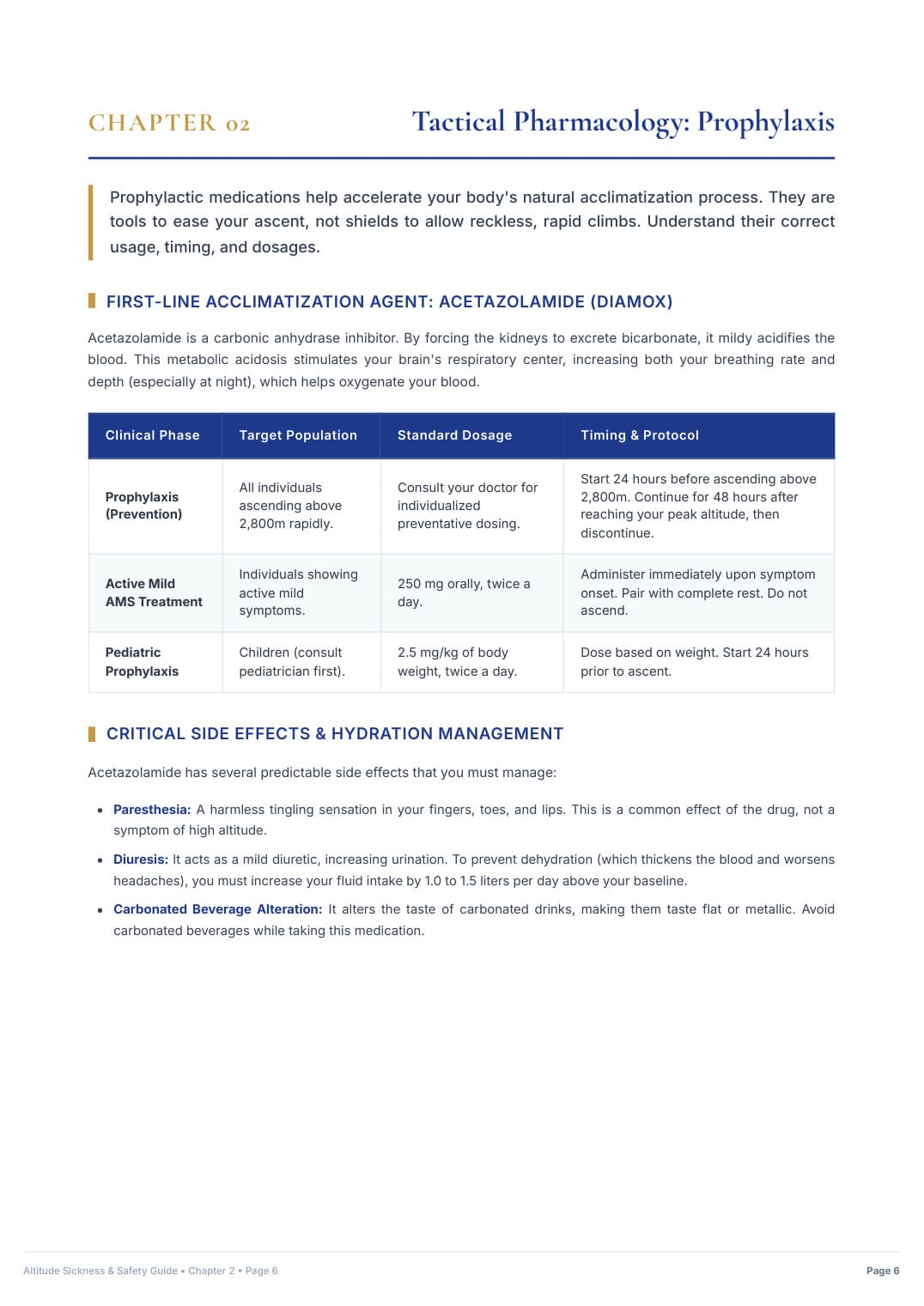
Hospital-Grade AMS Clinical Protocol
Emergency Medical Directive
Click to Enlarge Page

Hospital-Grade AMS Clinical Protocol

25-page acute mountain sickness emergency protocol, S.O.A.D. rapid descent workflow, and prescription medication matrix.

Verified Raw DossierZoom
↓ Choose Your Complete Uncensored Digital Pack Below ↓
Product 1 · Self-Drive Safety & Road Pass Dossier

G318 Overland Survival & Road Field Manual

The definitive self-drive road intelligence blueprint. Solves chassis clearance hazards, certified low-elevation sleep staging, and clinical acute mountain sickness protocols.

$39.90USD · Standalone Edition
Detailed Inclusions & Rights (全部实测权益):
66 Verified In-Vehicle Telemetry Tracks: Chengdu ➔ G318 South ➔ Lhasa ➔ Yamdrok Loop ➔ G317 North ➔ Chengdu Return Loop
10 Core Mountain Passes with Real Gradients & Clearance Ratings (Zheduo, Haizi, Dongda, Mila, etc.)
7 Golden Low-Altitude Overnight Sleep Havens (Safe Hypoxia Staging at Batang, Bomi, Nyingchi & more)
Mountain Road Blind Curves & Heavy Truck Overtaking Survival Rules (Break out of multi-mile slow convoys)
8 Severe Geohazard Blackspots (Active rockfalls, mudslides, riverbed washouts & black ice traps)
25-Page Hospital-Grade Acute Mountain Sickness (AMS) Clinical Protocol & Prescription Drug Matrix
Bilingual Medical & Police Emergency Flashcards (English & Chinese with phonetic pinyin)
100% Offline Access: High-Definition Mobile PDF (Zero cell signal needed on mountain passes)

Instant Single-File PDF Delivery (91 MB) · Standalone Survival Manual

Product 2 · Creators & Aerial Takeoff Archive

G318 Master 100 Drone & Photo Waypoints Pack

Dedicated visual takeoff archive. 100 curated spots with verified DJI EXIF coordinates, true ground elevations, golden-hour lighting windows, and universal offline map files.

$79.90USD · Standalone Edition
Detailed Inclusions & Rights (全部实测权益):
100 Curated Drone & Camera Master Waypoints (5 Thematic Chapters: Holy Mountains, Glaciers, Passes, Lakes, Kham Culture)
Extracted from Real DJI Drone EXIF Flight Data with Dual WGS-84 (Garmin/Google Earth) & GCJ-02 (Amap/Ovital) Coordinates
True Ground Elevations (Strictly Subtracted Drone Takeoff Altitudes for Precise Real-World Planning)
Universal Offline Map Pack: Ready-to-import KML files for Ovital Map, Amap (高德), and Google Earth + Excel/CSV Master Sheet
Calculated Golden Hour Lighting Windows & Sun Angles for Glaciers, Mountain Passes & Canyon Gorges
Pass-Specific & Canyon Safe Takeoff Protocols, Compass Calibration Rules & Gale-Force Wind Warnings
52-Page High-Res Illustrated English Drone Master Dossier (Full 100 Takeoff Spots with Visuals)
Instant Digital Delivery Archive (~24 MB): Illustrated PDF + Universal KML + Master Excel Sheet

Instant Digital Download (~24 MB): 52-Page Master PDF + KML Waypoints + Excel Sheet

👑 COMPLETE EXPEDITION PACKAGE · THE DEFINITIVE CREATOR BUNDLE
Best Value Deal · Save $19.90 USD

G318 Ultimate Overland & Creator Bundle

The all-in-one expedition master suite. Combines Product 1 (66 Telemetry Tracks Road Survival Manual) AND Product 2 (100 Verified Drone Waypoints Archive, Universal KML Maps & Master Excel Sheet) at a discounted package price.

$119.80$99.90USD · Full Bundle
Instant delivery of all PDF manuals, KML map files & photo archives
Everything Included in This Master Bundle (包含全部两大产品权益):
✓ INCLUDES COMPLETE PRODUCT 1: G318 Overland Survival & Road Field Manual ($39.90 Standalone Value)
✓ INCLUDES COMPLETE PRODUCT 2: Master 100 Drone & Photo Waypoints Pack ($79.90 Standalone Value)
66 Verified In-Vehicle Telemetry Tracks (Full Loop: Chengdu ➔ G318 ➔ Lhasa ➔ Yamdrok ➔ G317 ➔ Chengdu)
100 Verified Drone Takeoff Spots with Real DJI EXIF Coordinates & True Ground Elevations
Universal Offline KML & CSV Navigation Packs (Ready to import to Ovital Map, Amap, Google Earth & Garmin)
10 High-Altitude Passes with Elevation Profiles, Clearance Ratings & True Gradients
7 Golden Low-Altitude Overnight Sleep Havens (Safe Hypoxia Staging at Batang, Bomi, Nyingchi, etc.)
Mountain Road Blind Curves & Heavy Truck Overtaking Tactics (Break out of multi-mile convoys)
8 Severe Geohazard Blackspots (Landslides, debris flows, riverbed washouts & freeze-thaw ice traps)
25-Page Hospital-Grade Acute Mountain Sickness (AMS) Clinical Acclimatization & Rx Drug Protocol
Calculated Golden Hour Lighting Windows & Sun Angles for Glaciers, Mountain Passes & Canyon Gorges
Pass & Canyon Safe Takeoff Protocols, Compass Calibration Rules & Gale Wind Warnings
Bilingual Medical & Police Emergency Flashcards (English & Chinese with phonetic pinyin)
Instant Digital Delivery Archive (~40 MB Total): Illustrated PDFs + Universal KML + Master Excel Sheets
Unlock Complete 2027 Overland & Drone Master Package
Single-click payment via Stripe with immediate authenticated download link generated.
256-Bit Encrypted Stripe Checkout100% Offline Access · No Cell Signal NeededSupports Apple Pay, Google Pay, Visa & Amex